Sonar Maps offshore of Coal Oil Point
Click on the following images for a full size view of sonar survey maps acquired during 1994 to 1996 3.5 and 50 kHz sonar surveys.
The sonar studies of the hydrocarbon seeps send acoustic waves through the water column and record the presence of hydrocarbon bubbles as well as shallow sub-bottom geologic structure. Both 3.5 kHz and 50 kHz frequencies have been used. In the sonar profiles, we can see the bubble plumes as they travel from the seafloor to the sea surface.
The main goals include mapping seep locations and detecting temporal and spatial changes in seep discharge. We have historical data from the 1970's as well as several recent surveys to work with. One of the conclusions we made is that seepage surrounding oil platform Holly has diminished.
Our most recent 3.5 kHz survey in September, 1999 is, we believe, the most complete survey of the seeps location to date.
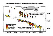
July-Sept. 1995 3.5 kHz survey

August 1996 3.5 kHz survey
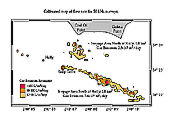
Calibrated 50 kHz survey map of discharge